Loading...
Changeset: 152847
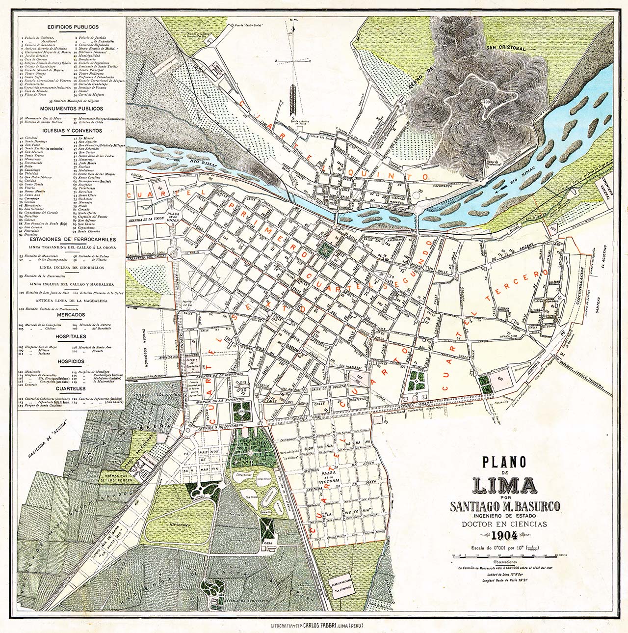
Calles añadidas según plano de Lima de 1904
Closed by El Surquillano
Tags
| changesets_count | 45 |
|---|---|
| created_by | iD 2.29.0-dev |
| host | https://www.openhistoricalmap.org/edit |
| ideditor:walkthrough_completed | yes |
| ideditor:walkthrough_progress | welcome;navigation;point;area;line;building;startEditing |
| ideditor:walkthrough_started | yes |
| imagery_used | OpenStreetMap (Standard) |
| locale | es |
| resolved:crossing_ways:building-highway | 1 |
| resolved:crossing_ways:highway-highway | 3 |
| resolved:missing_start_date | 2 |
| review_requested | yes |
| source:date | 1904 |
| source:name | Plano de Lima |
| source:url | https://lima2000.com/wp-content/uploads/2016/12/1904plano61.jpg |
| warnings:almost_junction:highway-highway | 1 |
| warnings:close_nodes:vertices | 1 |
| warnings:crossing_ways:building-highway | 3 |
| warnings:crossing_ways:highway-highway | 17 |
| warnings:crossing_ways:highway-railway | 28 |
| warnings:impossible_oneway:highway | 4 |
Discussion
Ways (1-20 of 63)
- Avenida Alfonso Ugarte [1928 – ] (200441875), v3
- Avenida Alfonso Ugarte [1928 – ] (200441877), v3
- Avenida Alfonso Ugarte [1928 – ] (200441879), v4
- Plaza Ramón Castilla [1871 – ] (200441881), v3
- Avenida 9 de Diciembre [1898 – ] (200441885), v3
- Avenida 9 de Diciembre [1898 – ] (200441886), v3
- Jirón Rufino Torrico [1535 – ] (200441913), v3
- Avenida Nicolás de Piérola [1905 – ] (200441920), v5
- Avenida Nicolás de Piérola [1905 – ] (200441921), v5
- Jirón Arequipa [1535 – 1971] (200441927), v4
- Avenida Enmacipación [1974 – ] (200441929), v2
- Avenida Enmacipación [1974 – ] (200441930), v3
- Avenida Miguel Grau [1904 – ] (200455016), v2
- Avenida Miguel Grau [1904 – ] (200455017), v2
- Jirón de la Unión [1535 – ] (200455021), v3
- Avenida Bolivia [1868 – ] (200455031), v2
- Avenida Bolivia [1940 – ] (200455034), v2
- Avenida Bolivia [1940 – ] (200455035), v2
- Avenida Uruguay [1924 – ] (200489110), v2
- Avenida Brasil [1940 – ] (200489113), v3
Nodes (1-20 of 103)
Welcome to OpenHistoricalMap!
OpenHistoricalMap is an interactive map of the world throughout history, created by people like you and dedicated to the public domain.
OpenHistoricalMap is a charter project of OpenStreetMap U.S., a 501(c)(3) nonprofit organization affiliated with the OpenStreetMap Foundation. Technical development is supported by GreenInfo Network and Development Seed.
| https://www.openhistoricalmap.org/copyright | https://www.openhistoricalmap.org |
| OpenHistoricalMap is dedicated to the public domain except where otherwise noted. | |