Loading...
Node: Sora [1800 – ] (2136358052)
Version #2
Medvode: vasi, hiše in krožišča
- Edited by Janez Pavel Žebovec
- Changeset #181672
- Location: 46.1418714, 14.3735918
Tags
| alt_name | Sovra |
|---|---|
| alt_name:de | Zeyer/Zaier |
| alt_name:source | Zgodovina Sorske in Preške fare (Anton Koblar;1883) |
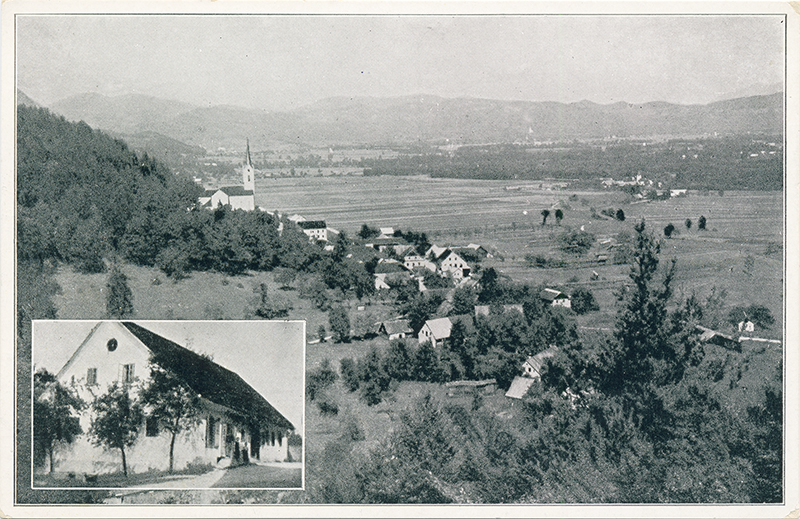
| image:1 | https://www.kamra.si/wp-content/uploads/2021/01/A_0363_K18a_1930_20171204_185337.jpg |
| image:1:caption | Posnetek Sore s pobočij Breznika |
| image:1:date | 1930~ |
| name | Sora |
| place | village |
| source:date | 18XX |
| source:name | Arcanum Maps - Europe in the XIX. century |
| source:url | https://maps.arcanum.com/en/map/europe-19century-secondsurvey/ |
| start_date | 1800 |
| start_date:edtf | /18XX |
Welcome to OpenHistoricalMap!
OpenHistoricalMap is an interactive map of the world throughout history, created by people like you and dedicated to the public domain.
OpenHistoricalMap is a charter project of OpenStreetMap U.S., a 501(c)(3) nonprofit organization affiliated with the OpenStreetMap Foundation. Technical development is supported by GreenInfo Network and Development Seed.
| https://www.openhistoricalmap.org/copyright | https://www.openhistoricalmap.org |
| OpenHistoricalMap is dedicated to the public domain except where otherwise noted. | |