Loading...
Relation: Hochstift Freising [1294 – 1802] (2695963)
Version #9
Added various itterations of the Duchy and Electorate of Bavaria
Tags
| admin_level | 4 |
|---|---|
| boundary | administrative |
| end_date | 1802-12-31 |
| license | CC0-1.0 |
| name | Hochstift Freising |
| name:de | Hochstift Freising |
| name:en | Prince-Bishopric of Freising |
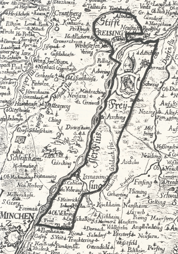
| source | Georg Philipp Finckh (1663–1671) "Grafschaft auf dem Yserrain" http://www.nordostkultur-muenchen.de/architektur/images/hochstift_freising_fink.gif https://de.wikipedia.org/wiki/Hochstift_Freising;Historischer Atlas von Bayerm, Altbayern Reihe I Heft 3 |
| start_date | 1294 |
| type | boundary |
Members
11 members
- Way 198724405 as outer
- Way 198305836 as outer
- Way 200157056 as outer
- Way 200178376 as outer
- Way 200178377 as outer
- Way 200178375 as outer
- Way 200561560 as outer
- Way 200178379 as outer
- Way 200561556 as outer
- Node Hochstift Freising [1294 – 1803] (2118145420) as label
- Relation Grafschaft Werdenfels [1294 – 1802] (2806949) as subarea
Welcome to OpenHistoricalMap!
OpenHistoricalMap is an interactive map of the world throughout history, created by people like you and dedicated to the public domain.
OpenHistoricalMap is a charter project of OpenStreetMap U.S., a 501(c)(3) nonprofit organization affiliated with the OpenStreetMap Foundation. Technical development is supported by GreenInfo Network and Development Seed.
| https://www.openhistoricalmap.org/copyright | https://www.openhistoricalmap.org |
| OpenHistoricalMap is dedicated to the public domain except where otherwise noted. | |