Loading...
Way: 200424203
Version #1
(no comment)
Tags
| quality | 1 |
|---|---|
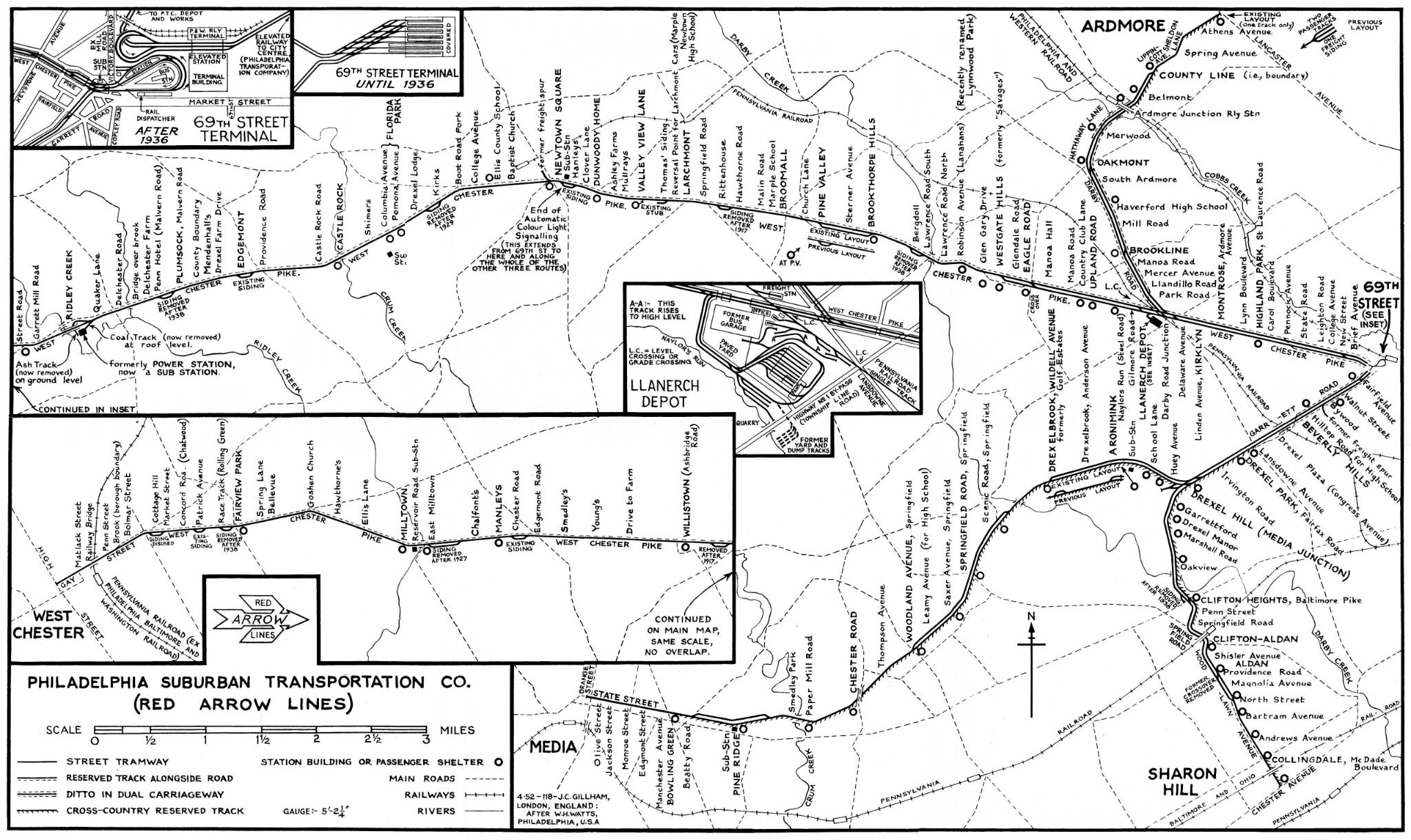
| source | Media, PA https://ngmdb.usgs.gov/topoview/ |
| source2 | (map) Philadelphia Suburban Transportation Co. (Red Arrow Lines) 1952, collection & restauration Jim Dornberger https://i.goopics.net/fux1g2.jpg |
| source_type | railway |
| type | source |
Nodes
52 nodes
- 2123119779 (part of ways 200424192 and 200424204)
-
2123119843 -
2123119842 -
2123119841 -
2123119840 -
2123119839 -
2123119838 -
2123119837 -
2123119836 -
2123119835 -
2123119834 -
2123119833 -
2123119832 -
2123119831 -
2123119830 -
2123119829 -
2123119828 -
2123119827 -
2123119826 -
2123119825 -
2123119824 -
2123119823 -
2123119822 -
2123119821 -
2123119820 -
2123119819 -
2123119818 -
2123119817 -
2123119816 -
2123119815 -
2123119814 -
2123119813 -
2123119812 -
2123119811 -
2123119810 -
2123119809 -
2123119808 -
2123119807 -
2123119806 -
2123119805 -
2123119804 -
2123119803 -
2123119802 -
2123119801 -
2123119800 -
2123119799 -
2123119798 -
2123119797 -
2123119796 -
2123119795 -
2123119794 -
2123119845
Welcome to OpenHistoricalMap!
OpenHistoricalMap is an interactive map of the world throughout history, created by people like you and dedicated to the public domain.
OpenHistoricalMap is a charter project of OpenStreetMap U.S., a 501(c)(3) nonprofit organization affiliated with the OpenStreetMap Foundation. Technical development is supported by GreenInfo Network and Development Seed.
| https://www.openhistoricalmap.org/copyright | https://www.openhistoricalmap.org |
| OpenHistoricalMap is dedicated to the public domain except where otherwise noted. | |