Loading...
Way: 200596263
Version #3
SNCV/NMVB Group Namur adding tram lines
Tags
| ! | please do not delete |
|---|---|
| quality | 1 |
| source:geometry | (map) Plan de Namur et des environs, late 1920, re-published in Namur de ligne en ligne, Rail Memories, décembre 2009, 144 p. (ISBN 978-2-9599732-5-3), p. 16 |
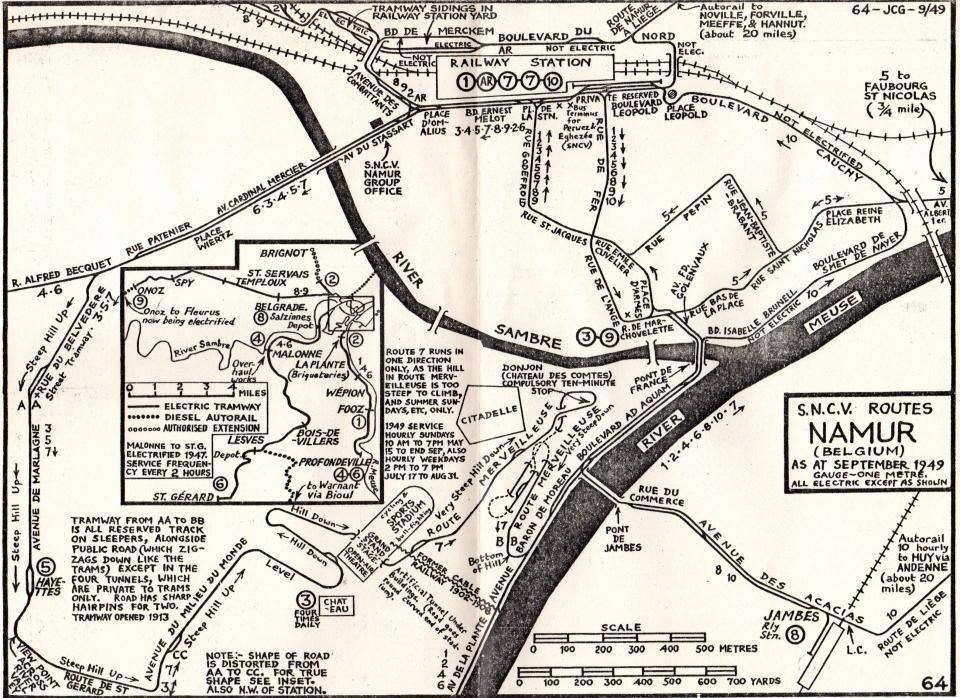
| source:geometry2 | (map) JC Gillham, S.N.C.V. Routes Namur (Belgium) as at september 1949 gauge-one metre. all electric except as shown https://i.goopics.net/7clva3.jpg |
| source_type | railway |
| type | source |
Nodes
36 nodes
- 2125465879 (part of ways 200596261 and 200596262)
- 2125465878
- 2125465877
- 2125465876
- 2125465875
- 2125465874
- 2125465873
- 2125465872
- 2125465871
- 2125465870
- 2125465869
- 2125465868
- 2125465867
- 2125465881
- 2125465866
- 2125465865
- 2125465864
- 2125465863
- 2125465862
- 2125465861
- 2125465860
- 2125465859
- 2125465858
- 2125465857
- 2125465856
- 2125465855
- 2125465854
- 2125465853
- 2125465852
- 2125427021
- 2125427020
- 2125427019
- 2125427018
- 2125427017
- 2125427016
- 2125427015 (part of way 200589413)
Welcome to OpenHistoricalMap!
OpenHistoricalMap is an interactive map of the world throughout history, created by people like you and dedicated to the public domain.
OpenHistoricalMap is a charter project of OpenStreetMap U.S., a 501(c)(3) nonprofit organization affiliated with the OpenStreetMap Foundation. Technical development is supported by GreenInfo Network and Development Seed.
| https://www.openhistoricalmap.org/copyright | https://www.openhistoricalmap.org |
| OpenHistoricalMap is dedicated to the public domain except where otherwise noted. | |