Loading...
Way History: 200605806
Version #9
TEPCE
Tags
| ! | used by multilinestring or multipolygon relations, please do not delete |
|---|---|
| geometry_class | railway |
| source:geometry | Institut géographique militaire/Militair geografisch instituut, Military staff map (available on kbr.be and http://cartesius.be/) |
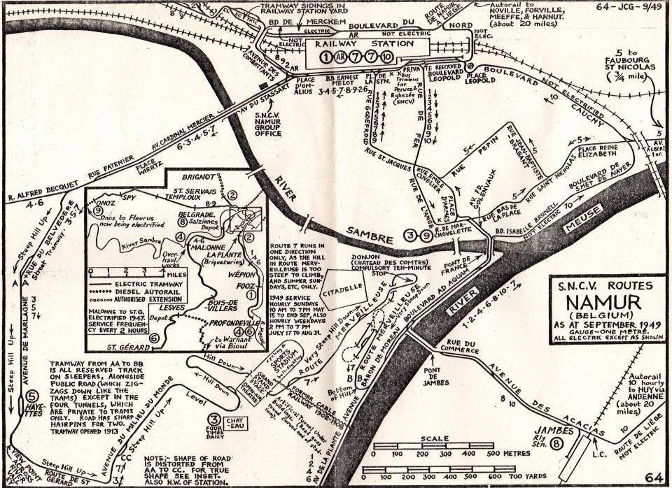
| source:geometry2 | (map) JC Gillham, S.N.C.V. Routes Namur (Belgium) as at september 1949 gauge-one metre. all electric except as shown https://i.goopics.net/7clva3.jpg |
Nodes
9 nodes
- 2125548574 (part of way 200605804)
- 2125548573
- 2125548572
- 2125548571
- 2125548570
- 2125548569
- 2125548568
- 2125548567
- 2125548575 (part of way 200605807)
Version #8
SNCV/NMVB Group Namur routes 544/1 & 6
Tags
| ! | used by multilinestring or multipolygon relations, please do not delete |
|---|---|
| geometry_class | railway |
| railway | tram |
| source:geometry | Institut géographique militaire/Militair geografisch instituut, Military staff map (available on kbr.be and http://cartesius.be/) |
| source:geometry2 | (map) JC Gillham, S.N.C.V. Routes Namur (Belgium) as at september 1949 gauge-one metre. all electric except as shown https://i.goopics.net/7clva3.jpg |
| start_date | 3000 |
Nodes
9 nodes
- 2125548574 (part of way 200605804)
- 2125548573
- 2125548572
- 2125548571
- 2125548570
- 2125548569
- 2125548568
- 2125548567
- 2125548575 (part of way 200605807)
Version #7
given, removing type=source and type=geometry from linestrings and points
Tags
| ! | used by multilinestring or multipolygon relations, please do not delete |
|---|---|
| geometry_class | railway |
| source:geometry | Institut géographique militaire/Militair geografisch instituut, Military staff map (available on kbr.be and http://cartesius.be/) |
| source:geometry2 | (map) JC Gillham, S.N.C.V. Routes Namur (Belgium) as at september 1949 gauge-one metre. all electric except as shown https://i.goopics.net/7clva3.jpg |
Nodes
9 nodes
- 2125548574 (part of way 200605804)
- 2125548573
- 2125548572
- 2125548571
- 2125548570
- 2125548569
- 2125548568
- 2125548567
- 2125548575 (part of way 200605807)
Version #6
(no comment)
Tags
| ! | used by multilinestring or multipolygon relations, please do not delete |
|---|---|
| geometry_class | railway |
| source:geometry | Institut géographique militaire/Militair geografisch instituut, Military staff map (available on kbr.be and http://cartesius.be/) |
| source:geometry2 | (map) JC Gillham, S.N.C.V. Routes Namur (Belgium) as at september 1949 gauge-one metre. all electric except as shown https://i.goopics.net/7clva3.jpg |
| type | geometry |
Nodes
9 nodes
- 2125548574 (part of way 200605804)
- 2125548573
- 2125548572
- 2125548571
- 2125548570
- 2125548569
- 2125548568
- 2125548567
- 2125548575 (part of way 200605807)
Version #5
(no comment)
Tags
| ! | used by multilinestring or multipolygon relations, please do not delete |
|---|---|
| source:geometry | Institut géographique militaire/Militair geografisch instituut, Military staff map (available on kbr.be and http://cartesius.be/) |
| source:geometry2 | (map) JC Gillham, S.N.C.V. Routes Namur (Belgium) as at september 1949 gauge-one metre. all electric except as shown https://i.goopics.net/7clva3.jpg |
| source_type | railway |
| type | source |
Nodes
9 nodes
- 2125548574 (part of way 200605804)
- 2125548573
- 2125548572
- 2125548571
- 2125548570
- 2125548569
- 2125548568
- 2125548567
- 2125548575 (part of way 200605807)
Version #4
(no comment)
Tags
| source:geometry | Institut géographique militaire/Militair geografisch instituut, Military staff map (available on kbr.be and http://cartesius.be/) |
|---|---|
| source:geometry2 | (map) JC Gillham, S.N.C.V. Routes Namur (Belgium) as at september 1949 gauge-one metre. all electric except as shown https://i.goopics.net/7clva3.jpg |
| source_type | railway |
| type | source |
Nodes
9 nodes
- 2125548574 (part of way 200605804)
- 2125548573
- 2125548572
- 2125548571
- 2125548570
- 2125548569
- 2125548568
- 2125548567
- 2125548575 (part of way 200605807)
Version #3
removing quality tags
Tags
| source:geometry | Institut géographique militaire/Militair geografisch instituut, Military staff map (available on kbr.be and http://cartesius.be/) |
|---|---|
| source:geometry2 | (map) JC Gillham, S.N.C.V. Routes Namur (Belgium) as at september 1949 gauge-one metre. all electric except as shown https://i.goopics.net/7clva3.jpg |
| source:geometry:guide | Service public de Wallonie (SPW), most recent aerial imagery https://geoportail.wallonie.be/ |
| source:geometry:guide:date | 2024 |
| source_type | railway |
| type | source |
Nodes
9 nodes
- 2125548574 (part of way 200605804)
- 2125548573
- 2125548572
- 2125548571
- 2125548570
- 2125548569
- 2125548568
- 2125548567
- 2125548575 (part of way 200605807)
Version #2
(no comment)
Tags
| quality | 1 |
|---|---|
| source:geometry | Institut géographique militaire/Militair geografisch instituut, Military staff map (available on kbr.be and http://cartesius.be/) |
| source:geometry2 | (map) JC Gillham, S.N.C.V. Routes Namur (Belgium) as at september 1949 gauge-one metre. all electric except as shown https://i.goopics.net/7clva3.jpg |
| source:geometry:guide | Service public de Wallonie (SPW), most recent aerial imagery https://geoportail.wallonie.be/ |
| source:geometry:guide:date | 2024 |
| source_type | railway |
| type | source |
Nodes
9 nodes
- 2125548574 (part of way 200605804)
- 2125548573
- 2125548572
- 2125548571
- 2125548570
- 2125548569
- 2125548568
- 2125548567
- 2125548575 (part of way 200605807)
Version #1
(no comment)
Tags
| quality | 1 |
|---|---|
| source:geometry | Institut géographique militaire/Militair geografisch instituut, Military staff map (available on kbr.be and http://cartesius.be/) |
| source:geometry:guide | Service public de Wallonie (SPW), most recent aerial imagery https://geoportail.wallonie.be/ |
| source:geometry:guide:date | 2024 |
| source_type | railway |
| type | source |
Nodes
8 nodes
Welcome to OpenHistoricalMap!
OpenHistoricalMap is an interactive map of the world throughout history, created by people like you and dedicated to the public domain.
OpenHistoricalMap is a charter project of OpenStreetMap U.S., a 501(c)(3) nonprofit organization affiliated with the OpenStreetMap Foundation. Technical development is supported by GreenInfo Network and Development Seed.
| https://www.openhistoricalmap.org/copyright | https://www.openhistoricalmap.org |
| OpenHistoricalMap is dedicated to the public domain except where otherwise noted. | |