Loading...
Way: Gimnazija Kranj [1903 – 1979] (200933425)
Version #2
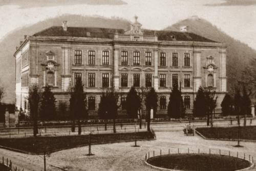
Stari Kranj
- Edited by Janez Pavel Žebovec
- Changeset #167787
Tags
| building | school |
|---|---|
| building:levels | 4 |
| end_date | 1979 |
| image | https://www.gimkr.si/pic/page/gimnazija-kranj-vcasih.jpg |
| name | Gimnazija Kranj |
| source:name | Gimnazija Kranj - Zgodovina šole |
| source:url | https://www.gimkr.si/o-soli/zgodovina-sole/ |
| start_date | 1903 |
| wikidata | Q60358113 |
Nodes
16 nodes
- 2131537083 (part of ways Gimnazija Kranj [1979 – ] (200933426), Gimnazija Kranj [1979 – ] (200933426), Gimnazija Kranj [1897 – 1903] (200972477), and Gimnazija Kranj [1897 – 1903] (200972477))
- 2131537084 (part of way Gimnazija Kranj [1979 – ] (200933426))
- 2131537087
- 2131537091 (part of way Gimnazija Kranj [1897 – 1903] (200972477))
- 2131537092 (part of way Gimnazija Kranj [1897 – 1903] (200972477))
- 2131537094 (part of way Gimnazija Kranj [1897 – 1903] (200972477))
- 2131537095 (part of way Gimnazija Kranj [1897 – 1903] (200972477))
- [1897 – 1979] (2131537098) (part of way Gimnazija Kranj [1897 – 1903] (200972477))
- 2131537093 (part of way Gimnazija Kranj [1897 – 1903] (200972477))
- 2131537096 (part of way Gimnazija Kranj [1897 – 1903] (200972477))
- 2131537090 (part of way Gimnazija Kranj [1897 – 1903] (200972477))
- 2131537089 (part of way Gimnazija Kranj [1897 – 1903] (200972477))
- 2131537088 (part of way Gimnazija Kranj [1897 – 1903] (200972477))
- 2131537085 (part of ways Gimnazija Kranj [1979 – ] (200933426) and Gimnazija Kranj [1897 – 1903] (200972477))
- 2131537086 (part of ways Gimnazija Kranj [1979 – ] (200933426) and Gimnazija Kranj [1897 – 1903] (200972477))
- 2131537083 (part of ways Gimnazija Kranj [1979 – ] (200933426), Gimnazija Kranj [1979 – ] (200933426), Gimnazija Kranj [1897 – 1903] (200972477), and Gimnazija Kranj [1897 – 1903] (200972477))
Welcome to OpenHistoricalMap!
OpenHistoricalMap is an interactive map of the world throughout history, created by people like you and dedicated to the public domain.
OpenHistoricalMap is a charter project of OpenStreetMap U.S., a 501(c)(3) nonprofit organization affiliated with the OpenStreetMap Foundation. Technical development is supported by GreenInfo Network and Development Seed.
| https://www.openhistoricalmap.org/copyright | https://www.openhistoricalmap.org |
| OpenHistoricalMap is dedicated to the public domain except where otherwise noted. | |