Loading...
Way: [1973 – ] (201123285)
Version #1
Added I-75 southbound in Scott County, Kentucky, and completed I-64/I-75 interchange in Fayette County, Kentucky.
- Edited by Ben Colclough
- Changeset #179020
Tags
| highway | motorway |
|---|---|
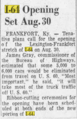
| source | I-64 Opening Set Aug. 30 |
| source:date | August 9, 1973 |
| source:name | The Lexington Leader |
| source:url | https://i.postimg.cc/1tGQd0z8/I64.png |
| start_date | 1973-08-30 |
Nodes
36 nodes
- 2135581789 (part of way I-64 [1973 – ] (201123299))
- 2135890281
- 2135890282
- 2135890283
- 2135890284
- 2135890285
- 2135890286
- 2135890287
- 2135890288
- 2135890289
- 2135890290
- 2135890291
- 2135890292
- 2135890293
- 2135890294
- 2135890295
- 2135890296
- 2135890297
- 2135890298
- 2135890299
- 2135890300
- 2135890301
- 2135890302
- 2135890303
- 2135890304
- 2135890305
- 2135890306
- 2135890307
- 2135890308
- 2135890309
- 2135890310
- 2135890311
- 2135890312
- 2135890313
- 2135890314
- 2135890317 (part of way [1973 – ] (201123287))
Welcome to OpenHistoricalMap!
OpenHistoricalMap is an interactive map of the world throughout history, created by people like you and dedicated to the public domain.
OpenHistoricalMap is a charter project of OpenStreetMap U.S., a 501(c)(3) nonprofit organization affiliated with the OpenStreetMap Foundation. Technical development is supported by GreenInfo Network and Development Seed.
| https://www.openhistoricalmap.org/copyright | https://www.openhistoricalmap.org |
| OpenHistoricalMap is dedicated to the public domain except where otherwise noted. | |