Loading...
Way: Tates Creek Road [1969 – ] (201123613)
Version #2
Added late 1960's and early 1970's houses and streets in Lexington, Kentucky.
- Edited by Ben Colclough
- Changeset #179055
Tags
| highway | primary |
|---|---|
| name | Tates Creek Road |
| oneway | yes |
| source | Map of East Lexington |
| source:date | 1971 |
| source:name | USGS |
| source:url | https://ngmdb.usgs.gov/ht-bin/tv_browse.pl?id=d9f539766cc05137d3e4db5d8b1b3586 |
| start_date | 1969-09 |
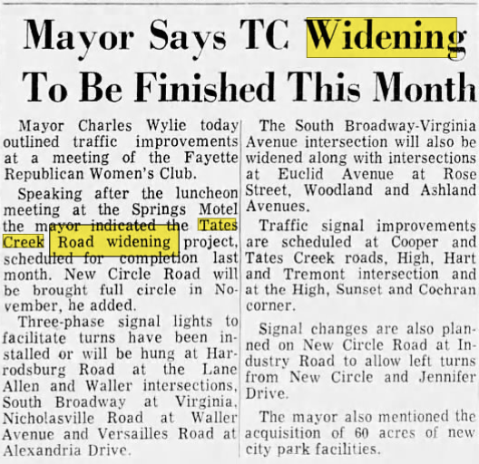
| start_date:source | https://i.postimg.cc/MKGfYp68/tates-creek-widening.png |
Nodes
71 nodes
- 2135200023 (part of ways Gainesway Drive [1959 – ] (201132219), [1861 – 1969] (201123616), and Tates Creek Road [1861 – 1969] (201070298))
- 2135894403 (part of way Tates Creek Road (KY 1972) [1969 – ] (201132214))
-
2135894404 - 2135894405 (part of ways Tates Creek Road (KY 1972) [1969 – ] (201132214) and [1959 – ] (201140603))
- 2135894406 (part of way Tates Creek Road (KY 1972) [1969 – ] (201132214))
- 2135894407 (part of way Tates Creek Road [1969 – ] (201132227))
- 2135894408 (part of way Tates Creek Road [1969 – ] (201132227))
- 2135894409
- 2135894410
- 2135894411
- 2135894412
- 2135894413 (part of way Dove Run Road [1981 – ] (201143584))
- 2135894414
- 2135894415
- 2135894416
- 2135894417
- 2135894418
- 2135896545 (part of way [1969 – ] (201124133))
- 2135894419
- 2135894420
- 2135894421
- 2135894536 (part of ways [1969 – ] (201123618) and Lansdowne Drive [1993 – ] (201139394))
- 2135894535 (part of ways [1969 – ] (201123617) and Lansdowne Drive [1993 – ] (201139395))
- 2135894422
- 2135894423
- 2135894424
- 2135894425
- 2135894537 (part of way [1969 – ] (201123619))
- 2135894426
- 2135894427
- 2135894538 (part of ways Albany Road [1965 – ] (201124134) and [1969 – ] (201123620))
- 2135894428
- 2135894429
- 2135894430
- 2135894431
- 2135894432
- 2135894539 (part of ways [1969 – ] (201123621) and [1978 – ] (201134726))
- 2135894433
- 2135894434
- 2135894435 (part of ways Mt Tabor Road [1861 – 1984] (201131379) and Old Mt Tabor Road [1984 – ] (201131390))
- 2135894436
- 2135894437
- 2135894438
- 2135894439
- 2135894540 (part of way [1969 – ] (201123623))
- 2135894440
- 2135894441
- 2135894442
- 2135894443
- 2135894444
- 2135894445
- 2135894446
- 2135894447
- 2135894448 (part of ways Mt Tabor Road [1980 – 1984] (201131377), Alumni Drive [1984 – ] (201131405), Stadium Road D [1976 – 1980] (201130724), and Alumni Drive [1980 – ] (201130731))
- 2135894449
- 2135894450
- 2135894451
- 2135894452
- 2135894453
- 2135894454
- 2135894455
- 2135894456
- 2135894457
- 2135894458
- 2135894459
- 2135894460
- 2135894461
- 2135894462
- 2135894463
- 2135894464
- 2135378112 (part of ways Montclair Drive [1934 – ] (201097080), [1861 – ] (201123615), Montclair [1940 – ] (201140946), Tates Creek Road [1861 – 1969] (201070298), Tates Creek Road [1969 – ] (201123614), and Lakewood Drive [1945 – ] (201081520))
Welcome to OpenHistoricalMap!
OpenHistoricalMap is an interactive map of the world throughout history, created by people like you and dedicated to the public domain.
OpenHistoricalMap is a charter project of OpenStreetMap U.S., a 501(c)(3) nonprofit organization affiliated with the OpenStreetMap Foundation. Technical development is supported by GreenInfo Network and Development Seed.
| https://www.openhistoricalmap.org/copyright | https://www.openhistoricalmap.org |
| OpenHistoricalMap is dedicated to the public domain except where otherwise noted. | |