Loading...
Way: Tates Creek Road [1969 – ] (201123614)
Version #3
Added Commonwealth Stadium (now officially called Kroger Field) in Lexington, Kentucky.
- Edited by Ben Colclough
- Changeset #179373
Tags
| highway | primary |
|---|---|
| name | Tates Creek Road |
| oneway | yes |
| source | Map of East Lexington |
| source:date | 1971 |
| source:name | USGS |
| source:url | https://ngmdb.usgs.gov/ht-bin/tv_browse.pl?id=d9f539766cc05137d3e4db5d8b1b3586 |
| start_date | 1969-09 |
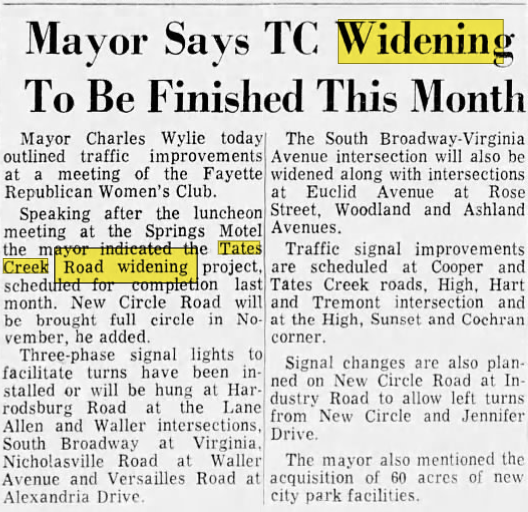
| start_date:source | https://i.postimg.cc/MKGfYp68/tates-creek-widening.png |
Nodes
77 nodes
- 2135378112 (part of ways Montclair Drive [1934 – ] (201097080), [1861 – ] (201123615), Montclair [1940 – ] (201140946), Tates Creek Road [1861 – 1969] (201070298), Tates Creek Road [1969 – ] (201123613), and Lakewood Drive [1945 – ] (201081520))
- 2135894534 (part of way Montclair [1940 – ] (201140946))
- 2135894533
- 2135894532
- 2135894531
- 2135894530
- 2135894529
- 2135894528
- 2135894527
- 2135894526
- 2135894525
- 2135894524
- 2135894523 (part of way McMeekin Place [1987 – ] (201134920))
- 2135894522
- 2135894521 (part of way Cottage Grove Lane [1978 – ] (201134724))
- 2135894520
- 2135894519
- 2135995336 (part of ways Stadium Road D [1976 – 1980] (201130723) and Alumni Drive [1980 – ] (201130730))
- 2135995334 (part of ways Stadium Road D [1976 – 1980] (201130724) and Alumni Drive [1980 – ] (201130731))
- 2135894518 (part of way Shadeland [1959 – ] (201152923))
- 2135894517 (part of way Shadeland [1959 – ] (201152923))
- 2135894516 (part of way Shadeland [1959 – ] (201152923))
- 2135894515 (part of way Shadeland [1959 – ] (201152923))
- 2135894514 (part of way Shadeland [1959 – ] (201152923))
- 2135894513 (part of way Shadeland [1959 – ] (201152923))
- 2135894512 (part of way Shadeland [1959 – ] (201152923))
- 2135894511 (part of ways Old Dobbin Road [1965 – ] (201106762) and Shadeland [1959 – ] (201152923))
- 2135894510 (part of way Shadeland [1959 – ] (201152923))
- 2135894509 (part of way Shadeland [1959 – ] (201152923))
- 2135894508 (part of way Shadeland [1959 – ] (201152923))
- 2135894507 (part of way [1964 – ] (201153855))
- 2135894506 (part of ways [1969 – ] (201123622), Old Mt Tabor Road [1984 – ] (201131390), and [1964 – ] (201153855))
- 2135894505 (part of way [1964 – ] (201153855))
- 2135894504 (part of way Hinds Heights [1953 – ] (201153847))
- 2135894503 (part of ways Rebecca Drive [1954 – ] (201103996) and Hinds Heights [1953 – ] (201153847))
- 2135894502 (part of way Hinds Heights [1953 – ] (201153847))
- 2135894501 (part of way Hinds Heights [1953 – ] (201153847))
- 2135894500 (part of way Hinds Heights [1953 – ] (201153847))
- 2135894499 (part of way Hinds Heights [1953 – ] (201153847))
- 2135894498 (part of way Hinds Heights [1953 – ] (201153847))
- 2135894497 (part of way Hinds Heights [1953 – ] (201153847))
- 2135894496 (part of way Hinds Heights [1953 – ] (201153847))
- 2135894495 (part of ways Hinds Heights [1953 – ] (201153847) and Albany Road [1954 – ] (201103995))
- 2135894494 (part of way Hinds Heights [1953 – ] (201153847))
- 2135894493 (part of way Hinds Heights [1953 – ] (201153847))
- 2135894492 (part of ways Robin Road [1954 – ] (201104005) and Lansdowne [1954 – ] (201153845))
- 2135894491 (part of way Lansdowne [1954 – ] (201153845))
- 2135894490 (part of way Lansdowne [1954 – ] (201153845))
- 2135894489 (part of way Lansdowne [1954 – ] (201153845))
- 2135894488 (part of way Lansdowne [1954 – ] (201153845))
- 2135894487 (part of ways Lansdowne [1954 – ] (201153845) and Lansdowne Drive [1965 – ] (201106297))
- 2135894486 (part of ways Lansdowne Drive [1965 – ] (201106296) and Lansdowne [1954 – ] (201153845))
- 2135894485 (part of way Lansdowne [1954 – ] (201153845))
- 2135894484 (part of way Lansdowne [1954 – ] (201153845))
- 2135894483 (part of way Lansdowne [1954 – ] (201153845))
- 2135894482 (part of ways Raven Road [1965 – ] (201106328) and Lansdowne [1954 – ] (201153845))
- 2135894481 (part of way Lansdowne [1954 – ] (201153845))
- 2135894480
- 2135894479
- 2135894478
- 2135894477
- 2135894476
- 2135894475
- 2135894474
- 2135894473
- 2135925445 (part of way [1969 – ] (201127766))
- 2135894472
- 2135925434 (part of way [1969 – ] (201127765))
- 2135894471
- 2135894470
- 2135925454 (part of ways [1969 – ] (201127769), [1969 – ] (201132226), and Tates Creek Road (KY 1972) [1969 – ] (201132225))
- 2135894469 (part of way Tates Creek Road (KY 1972) [1969 – ] (201132225))
- 2135894468 (part of way Tates Creek Road (KY 1972) [1969 – ] (201132225))
- 2135894467 (part of way Tates Creek Road (KY 1972) [1969 – ] (201132225))
- 2135894466 (part of way Tates Creek Road (KY 1972) [1969 – ] (201132225))
- 2135894465 (part of way Tates Creek Road (KY 1972) [1969 – ] (201132225))
- 2135200023 (part of ways Gainesway Drive [1959 – ] (201132219), [1861 – 1969] (201123616), and Tates Creek Road [1861 – 1969] (201070298))
Welcome to OpenHistoricalMap!
OpenHistoricalMap is an interactive map of the world throughout history, created by people like you and dedicated to the public domain.
OpenHistoricalMap is a charter project of OpenStreetMap U.S., a 501(c)(3) nonprofit organization affiliated with the OpenStreetMap Foundation. Technical development is supported by GreenInfo Network and Development Seed.
| https://www.openhistoricalmap.org/copyright | https://www.openhistoricalmap.org |
| OpenHistoricalMap is dedicated to the public domain except where otherwise noted. | |