Loading...
Way: I-64 [1973 – ] (201129237)
Version #1
Extended I-64 from Lexington, KY to Frankfort, KY.
- Edited by Ben Colclough
- Changeset #179354
Tags
| highway | motorway |
|---|---|
| name | I-64 |
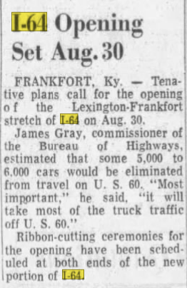
| source | I-64 Opening Set Aug. 30 |
| source:date | August 9, 1973 |
| source:name | The Lexington Leader |
| source:url | https://i.postimg.cc/1tGQd0z8/I64.png |
| start_date | 1973-08-30 |
Nodes
47 nodes
- 2135969467 (part of way I-64 [1973 – ] (201129239))
- 2135969465
- 2135969464
- 2135969463
- 2135969462
- 2135969461
- 2135969460
- 2135969458
- 2135969457
- 2135969456
- 2135969455
- 2135969454
- 2135969453
- 2135969452
- 2135969451
- 2135969450
- 2135969449
- 2135969448
- 2135969447
- 2135969446
- 2135969445
- 2135969444
- 2135969443
- 2135969442
- 2135969441
- 2135969440
- 2135969439
- 2135969438
- 2135969437
- 2135969436
- 2135969435
- 2135969434
- 2135969433
- 2135969432
- 2135969431
- 2135969430
- 2135969429
- 2135969428
- 2135969427
- 2135969426
- 2135969425
- 2135969424
- 2135969423
- 2135969422
- 2135969421
- 2135969420
- 2135968166 (part of ways 199752725 and I-64 [1973 – ] (201123299))
Welcome to OpenHistoricalMap!
OpenHistoricalMap is an interactive map of the world throughout history, created by people like you and dedicated to the public domain.
OpenHistoricalMap is a charter project of OpenStreetMap U.S., a 501(c)(3) nonprofit organization affiliated with the OpenStreetMap Foundation. Technical development is supported by GreenInfo Network and Development Seed.
| https://www.openhistoricalmap.org/copyright | https://www.openhistoricalmap.org |
| OpenHistoricalMap is dedicated to the public domain except where otherwise noted. | |