Loading...
Relation: Königreich Dalmatien [1815 – 1878] (2690520)
Version #31
Amended some boundaries in Dalmatia to conform with the Habsburg surveys
Tags
| admin_level | 4 |
|---|---|
| boundary | administrative |
| end_date | 1878-07-13 |
| end_date:changes | gained Sutomore |
| end_event | Treaty of Berlin |
| end_event:wikidata | Q1048169 |
| fixme | confirm border definition of islands between Istria and Dalmatia |
| fixme:place | need to figure out what places these are... |
| fixme:sa | remove subareas? |
| fixme:start_date | make sure established by the Congress and not shortly after |
| name | Königreich Dalmatien |
| name:de | Königreich Dalmatien |
| name:en | Kingdom of Dalmatia |
| place | state |
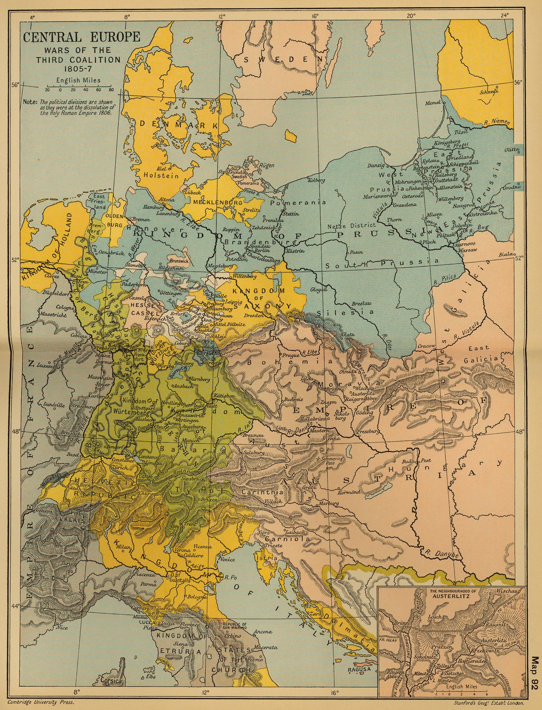
| source | https://maps.lib.utexas.edu/maps/historical/ward_1912/europe_central_1805.jpg |
| source:name | Central Europe: Wars of the Third Coalition 1805-7'; from 'Cambridge Modern History Atlas', 1912 |
| start_date | 1815-06-09 |
| start_event | Congress of Vienna |
| start_event:wikidata | Q46362 |
| type | boundary |
| wikidata | Q698248 |
| wikipedia | en:Kingdom of Dalmatia |
Members
68 members
- Way 201046975 as outer
- Way 201046978 as outer
- Way 201046987 as outer
- Way 201046989 as outer
- Way 201046984 as outer
- Way 201046990 as outer
- Way 198557013 as outer
- Way 198567373 as outer
- Way 201046804 as outer
- Way 201046815 as outer
- Way 199612932 as outer
- Way 201046798 as outer
- Way 201046797 as outer
- Way 198693441 as outer
- Way 201045617 as outer
- Way 201045613 as outer
- Way 3NM offshore line for empires and large area relations (200915848) as outer
- Way 3NM offshore line for empires and large area relations (201046807) as outer
- Way 3NM offshore line for empires and large area relations (200931652) as outer
- Way 3NM offshore line for empires and large area relations (200915666) as outer
- Way 3NM offshore line for empires and large area relations (200915668) as outer
- Way cartographic adjustment (200916774) as outer
- Way cartographic bridge (200916775) as outer
- Way cartographic adjustment (200916773) as outer
- Way 3NM offshore line for empires and large area relations (200916772) as outer
- Way 3NM offshore line for empires and large area relations (200915667) as outer
- Way 201046972 as outer
- Way 201046968 as outer
- Way 201046963 as outer
- Way 201046962 as outer
- Way 201046954 as outer
- Way Vis 3NM offshore line for empires and large area relations (201046953) as outer
- Way 201046957 as outer
- Way Svetac 3NM offshore line for empires and large area relations (201046955) as outer
- Way 201046956 as outer
- Way 201046967 as outer
- Way 201046948 as outer
- Way 201046961 as outer
- Way 201046960 as outer
- Way 3NM offshore line for empires and large area relations (201046959) as outer
- Way 3NM offshore line for empires and large area relations (200931314) as outer
- Way 3NM offshore line for empires and large area relations (200931317) as outer
- Way 3NM offshore line for empires and large area relations (200931320) as outer
- Way 200913445 as outer
- Way 3.2NM offshore line for empires and large area relations (200916767) as outer
- Way cartographic bridge (200916766) as outer
- Way cartographic bridge (200916768) as outer
- Way cartographic bridge (200916765) as outer
- Way 3.2NM offshore line for empires and large area relations (200916770) as outer
- Way 3NM offshore line for empires and large area relations (200931331) as outer
- Way 3.2NM offshore line for empires and large area relations (200931329) as outer
- Way 3NM offshore line for empires and large area relations (200916771) as outer
- Way 199600482 as outer
- Way 198750298 as outer
- Way 200917057 as outer
- Way 200495800 as outer
- Way 200547085 as outer
- Way 198567175 as outer
- Way 198532410 as outer
- Way 200176629 as outer
- Way 201046986 as outer
- Way Sušac 3NM offshore line for empires and large area relations (200910003) as outer
- Way Lastovo 3NM offshore line for empires and large area relations (201046825) as outer
- Way Lastovo 3NM offshore line for empires and large area relations (200910005) as outer
- Way 3.2NM offshore line for empires and large area relations (200910004) as outer
- Relation Kreis Cattaro [1822 – 1868] (2829039) as subarea
- Relation Kreis Ragusa [1822 – 1868] (2829038) as subarea
- Node Dalmatien [1815 – 1918] (2104060595) as label
Welcome to OpenHistoricalMap!
OpenHistoricalMap is an interactive map of the world throughout history, created by people like you and dedicated to the public domain.
OpenHistoricalMap is a charter project of OpenStreetMap U.S., a 501(c)(3) nonprofit organization affiliated with the OpenStreetMap Foundation. Technical development is supported by GreenInfo Network and Development Seed.
| https://www.openhistoricalmap.org/copyright | https://www.openhistoricalmap.org |
| OpenHistoricalMap is dedicated to the public domain except where otherwise noted. | |